
Introduction
A Terminal Aerodrome Forecast, commonly called a TAF, is one of the most important weather-planning products used in aviation.
While a METAR tells pilots what the weather was at the time of observation, a TAF describes the weather expected at an aerodrome during a stated future period.
For Indian pilot students, learning to decode a TAF is essential for planning:
- Circuit training
- First solo flights
- Cross-country navigation
- Departures and arrivals
- Alternate aerodromes
- Fuel reserves
- Weather diversions
- Return-to-base decisions
TAF reports may appear complicated because they contain several time periods and change groups. However, the report follows a logical sequence. Once students understand the format, they can identify the expected wind, visibility, weather, clouds, and possible changes during the flight.
This guide explains each major TAF group in simple language and shows how to interpret the complete forecast safely.
What Is a TAF?
TAF stands for Terminal Aerodrome Forecast.
It is a coded forecast describing expected weather conditions at or near an aerodrome during a specified validity period.
A TAF may include:
- Aerodrome identifier
- Forecast issue time
- Validity period
- Forecast surface wind
- Forecast visibility
- Expected weather
- Forecast cloud layers
- Significant changes
- Temporary weather fluctuations
- Probability groups
- Maximum and minimum temperatures, where included
- Cancellation, correction, or amendment information
A TAF is a forecast rather than an observation. Actual weather may differ from the forecast, so pilots must compare it with the latest METAR, SPECI, warnings, and other available weather information.
Why TAF Knowledge Is Important
A TAF helps student pilots answer questions such as:
- Will visibility remain suitable during the flight?
- Is fog expected before departure or return?
- Will the cloud base become too low?
- Are thunderstorms forecast?
- Will the wind become stronger or change direction?
- Could the crosswind exceed student limits?
- Is temporary heavy rain expected?
- Will the destination remain suitable?
- Is the alternate aerodrome likely to remain available?
- Should additional fuel be carried?
Correct TAF interpretation supports safe decision-making before the aircraft leaves the ground.
TAF and METAR Difference
| Feature | TAF | METAR |
|---|---|---|
| Main purpose | Forecast future aerodrome weather | Reports observed aerodrome weather |
| Time coverage | Covers a stated validity period | Represents conditions at observation time |
| Information type | Predicted conditions | Actual observed conditions |
| Change groups | FM, BECMG, TEMPO, PROB | May contain a short trend |
| Main use | Flight planning | Current weather assessment |
| Used alone | No | No |
A student pilot should normally compare the current METAR with the relevant TAF.
For example, a METAR may show good visibility now, while the TAF may predict fog before the expected return time.
Standard TAF Reading Order
A TAF generally follows this sequence:
Report type → Airport → Issue time → Validity period → Main forecast → Change groups
The main forecast commonly includes:
Wind → Visibility → Weather → Clouds
A useful memory pattern is:
Airport, time, validity, wind, visibility, weather, cloud, changes
Basic Training TAF Example
Consider this fictional TAF:
TAF VIDP 160500Z 1606/1712 25008KT 5000 HZ SCT020 BECMG 1610/1612 28012KT 7000 TEMPO 1614/1618 3000 TSRA SCT015 FEW030CB
This is a training example and not a current operational forecast.
The complete forecast can be summarized as follows:
A TAF for Delhi was issued on the 16th at 05:00 UTC. It is valid from the 16th at 06:00 UTC until the 17th at 12:00 UTC. Initially, wind is forecast from 250 degrees at 8 knots, visibility 5 kilometres in haze, with scattered clouds at 2,000 feet. Between 10:00 and 12:00 UTC, the wind is forecast to become 280 degrees at 12 knots and visibility 7 kilometres. Temporary thunderstorm rain, visibility of 3 kilometres, scattered clouds at 1,500 feet, and a few cumulonimbus clouds at 3,000 feet are expected between 14:00 and 18:00 UTC.
Let us decode every group.
TAF
The word TAF identifies the report as a Terminal Aerodrome Forecast.
Other markings that may appear include:
- AMD – amended forecast
- COR – corrected forecast
- CNL – cancelled forecast
- NIL – forecast unavailable
An amended TAF replaces or modifies an earlier forecast because expected conditions have changed significantly or the original forecast requires revision.
Students should always confirm that they are reading the most recent valid TAF.
VIDP
VIDP is the ICAO location indicator for Delhi’s Indira Gandhi International Airport.
Some commonly recognized Indian ICAO identifiers include:
| ICAO code | Airport or city |
|---|---|
| VIDP | Delhi |
| VABB | Mumbai |
| VOBL | Bengaluru |
| VOMM | Chennai |
| VECC | Kolkata |
| VOHS | Hyderabad |
| VAAH | Ahmedabad |
| VIJP | Jaipur |
| VAPO | Pune |
| VOCI | Kochi |
| VOGO | Goa |
| VEGT | Guwahati |
Always confirm that the TAF belongs to the correct departure, destination, or alternate aerodrome.
160500Z
This is the TAF issue time.
- 16 means the 16th day of the month.
- 0500 means 05:00 UTC.
- Z means UTC or Zulu time.
India Standard Time is UTC plus 5 hours and 30 minutes.
Therefore:
05:00 UTC = 10:30 IST
The issue time tells the student when the forecast was prepared. It is different from the forecast validity period.
1606/1712
This is the TAF validity period.
- 1606 means the forecast begins on the 16th at 06:00 UTC.
- 1712 means it ends on the 17th at 12:00 UTC.
In Indian Standard Time:
- Beginning: 11:30 IST on the 16th
- Ending: 17:30 IST on the 17th
The TAF is therefore valid across two calendar days.
A common student mistake is reading the validity period as one single time rather than a starting and ending time.
25008KT
This is the forecast surface wind.
- 250 means the wind is expected from 250 degrees.
- 08 means 8 knots.
- KT means knots.
The wind is forecast from 250 degrees at 8 knots.
Gusting Wind in a TAF
Example:
24012G22KT
This means:
- Wind from 240 degrees
- Average speed 12 knots
- Gusting to 22 knots
The gust value may affect:
- Student crosswind limits
- Circuit training
- Approach stability
- Landing technique
- Take-off planning
- Go-around decisions
Variable Wind
Example:
VRB03KT
This means the wind direction is expected to be variable at 3 knots.
Variable wind can make runway selection and circuit planning less predictable.
Calm Wind
00000KT means calm wind is forecast.
Calm surface wind does not guarantee calm conditions at circuit altitude or along the route.
5000
This is the forecast prevailing visibility.
5000 means 5,000 metres or 5 kilometres.
Other examples include:
| Code | Meaning |
|---|---|
| 0800 | 800 metres |
| 1500 | 1,500 metres |
| 3000 | 3 kilometres |
| 6000 | 6 kilometres |
| 9999 | 10 kilometres or more |
The code 9999 means visibility is forecast to be at least 10 kilometres. It does not mean unlimited visibility.
HZ
HZ means haze.
Haze is common in several Indian regions and can affect:
- Horizon definition
- Landmark recognition
- Traffic detection
- Runway identification
- Visual navigation
- Distance judgement
The visibility value and weather code should be interpreted together.
For example:
3000 HZ
This means visibility of 3 kilometres in haze.
Common Weather Codes in TAF
Visibility and Obscuration
| Code | Meaning |
|---|---|
| BR | Mist |
| FG | Fog |
| HZ | Haze |
| FU | Smoke |
| DU | Widespread dust |
| SA | Sand |
| VA | Volcanic ash |
Precipitation
| Code | Meaning |
|---|---|
| RA | Rain |
| DZ | Drizzle |
| SN | Snow |
| SH | Showers |
| GR | Hail |
| GS | Small hail or snow pellets |
Significant Weather
| Code | Meaning |
|---|---|
| TS | Thunderstorm |
| SQ | Squall |
| FC | Funnel cloud or tornado |
| DS | Dust storm |
| SS | Sandstorm |
| FZ | Freezing |
| BL | Blowing |
| DR | Low drifting |
| VC | In the vicinity |
Weather Intensity
A symbol may appear before the weather code:
- – means light.
- No symbol normally means moderate.
- + means heavy.
Examples:
- -RA – light rain
- RA – moderate rain
- +RA – heavy rain
- -TSRA – thunderstorm with light rain
- +TSRA – thunderstorm with heavy rain
- VCTS – thunderstorm in the vicinity
SCT020
This is the forecast cloud group.
- SCT means scattered clouds.
- 020 means the cloud base is expected at 2,000 feet above the aerodrome.
The cloud height is written in hundreds of feet.
Examples:
- 005 – 500 feet
- 010 – 1,000 feet
- 020 – 2,000 feet
- 050 – 5,000 feet
- 100 – 10,000 feet
Cloud Amount Codes
| Code | Meaning | Approximate coverage |
|---|---|---|
| FEW | Few clouds | 1–2 oktas |
| SCT | Scattered clouds | 3–4 oktas |
| BKN | Broken clouds | 5–7 oktas |
| OVC | Overcast | 8 oktas |
| NSC | No significant cloud | No significant operational cloud forecast |
| VV | Vertical visibility | Sky expected to be obscured |
Examples:
- FEW015 – few clouds at 1,500 feet
- SCT025 – scattered clouds at 2,500 feet
- BKN012 – broken clouds at 1,200 feet
- OVC006 – overcast clouds at 600 feet
- VV002 – vertical visibility 200 feet
Cloud Ceiling
The operational ceiling is normally associated with the lowest forecast layer reported as:
- Broken
- Overcast
- Vertical visibility
Example:
SCT015 BKN025
This means:
- Scattered clouds at 1,500 feet
- Broken clouds at 2,500 feet
The forecast ceiling is 2,500 feet.
Student pilots should compare the ceiling with:
- Circuit altitude
- Training-area requirements
- Terrain elevation
- Visual flight rules
- School limits
- Personal limits
Cumulonimbus and Towering Cumulus
Two cloud codes require special attention:
- CB – cumulonimbus
- TCU – towering cumulus
Example:
FEW030CB
This means a few cumulonimbus clouds with bases at 3,000 feet.
Cumulonimbus clouds may produce:
- Thunderstorms
- Lightning
- Heavy rain
- Hail
- Severe turbulence
- Wind shear
- Downdrafts
- Microbursts
Example:
SCT025TCU
This means scattered towering cumulus clouds with bases at 2,500 feet.
TCU may indicate developing convective activity.
Main Forecast Conditions
The first wind, visibility, weather, and cloud groups after the validity period form the initial forecast conditions.
In the example:
25008KT 5000 HZ SCT020
This means:
- Wind from 250 degrees at 8 knots
- Visibility 5 kilometres
- Haze
- Scattered clouds at 2,000 feet
These conditions remain the main forecast until a change group modifies them.
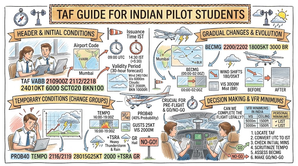
BECMG Explained
BECMG means becoming.
It indicates that the weather is expected to change gradually during a stated time period.
Example:
BECMG 1610/1612 28012KT 7000
This means that between the 16th at 10:00 UTC and 12:00 UTC, conditions are expected to become:
- Wind from 280 degrees at 12 knots
- Visibility 7 kilometres
The change may begin at any time within the BECMG period and should be completed by the end of that period.
Once the change is complete, the new conditions become the forecast baseline.
How to Interpret BECMG
Suppose the forecast says:
BECMG 1608/1610 BKN015
This means the cloud condition will gradually become broken at 1,500 feet sometime between 08:00 and 10:00 UTC.
For conservative planning, students should consider that the change may begin near the start of the period, especially when the new condition is worse.
TEMPO Explained
TEMPO means temporary fluctuations are expected.
Example:
TEMPO 1614/1618 3000 TSRA SCT015 FEW030CB
This means temporary conditions are expected between the 16th at 14:00 UTC and 18:00 UTC:
- Visibility 3 kilometres
- Thunderstorm with rain
- Scattered clouds at 1,500 feet
- Few cumulonimbus clouds at 3,000 feet
These conditions are not necessarily expected throughout the entire four-hour period. They may occur temporarily within it.
However, the possibility must still be considered during flight planning.
TEMPO and Flight Decisions
A student should not ignore TEMPO conditions because they are temporary.
Temporary weather may still affect:
- Departure
- Arrival
- Return to base
- Alternate availability
- Fuel requirements
- Route selection
- Circuit training
- Solo authorization
A temporary thunderstorm or low-cloud period can be operationally important even if the main forecast appears acceptable.
FM Explained
FM means from.
It introduces a new set of forecast conditions beginning at a specific time.
Example:
FM161500 27015KT 4000 RA BKN012
This means that from the 16th at 15:00 UTC, the forecast becomes:
- Wind from 270 degrees at 15 knots
- Visibility 4 kilometres
- Rain
- Broken cloud at 1,200 feet
The FM group normally replaces the previous main forecast conditions from the stated time.
FM Time Format
An FM group normally includes:
- Day
- Hour
- Minute
Example:
FM170630
This means from the 17th at 06:30 UTC.
The time is more precise than a BECMG period.
Difference Between FM and BECMG
| Change group | Meaning |
|---|---|
| FM | New conditions begin from a specific time |
| BECMG | Conditions gradually change during a stated time window |
Example:
FM161200
A new weather pattern begins from 12:00 UTC.
Example:
BECMG 1612/1614
The change develops gradually between 12:00 and 14:00 UTC.
PROB30 and PROB40
Probability groups indicate the chance of specified weather conditions occurring.
- PROB30 means a 30% probability.
- PROB40 means a 40% probability.
Example:
PROB30 1612/1616 TSRA
This means there is a 30% probability of thunderstorm rain between 12:00 and 16:00 UTC.
Another example:
PROB40 TEMPO 1614/1618 2000 +TSRA
This means there is a 40% probability of temporary visibility of 2 kilometres in heavy thunderstorm rain during the stated period.
Should Students Ignore PROB30?
No.
A 30% probability may still be operationally important when the possible weather includes:
- Thunderstorms
- Very low visibility
- Severe wind
- Heavy rain
- Low cloud
- Freezing precipitation
- Dust storms
Probability must be considered together with the seriousness of the hazard.
NOSIG and TAF
NOSIG is most commonly seen as a short-term trend attached to a METAR or SPECI rather than as the main structure of a full TAF.
It means no significant change is expected during the applicable trend period.
NOSIG does not mean the weather will remain perfectly unchanged.
CAVOK in TAF
CAVOK may be used when specified visibility, weather, and cloud conditions are expected to meet required criteria.
It generally means:
- Visibility of 10 kilometres or more
- No significant forecast weather
- No operationally significant low cloud
- No CB or TCU requiring reporting
CAVOK does not necessarily mean there will be no clouds anywhere.
NSC Meaning
NSC means no significant cloud.
It may be used when no operationally significant cloud is forecast and CAVOK is not appropriate.
Students should not automatically interpret NSC as a completely clear sky.
Maximum and Minimum Temperature Groups
Some TAF formats may include forecast maximum and minimum temperatures.
Examples:
TX35/1610Z
This means:
- Maximum temperature of 35°C
- Expected on the 16th at 10:00 UTC
TN22/1622Z
This means:
- Minimum temperature of 22°C
- Expected on the 16th at 22:00 UTC
Temperature forecasts may help pilots assess:
- Density altitude
- Aircraft performance
- Fog risk
- Frost risk
- Icing potential
- Heat-related operational concerns
Monsoon TAF Example
Consider this fictional training example:
TAF VOMM 160500Z 1606/1712 16010KT 6000 SCT020 TEMPO 1608/1612 3000 SHRA BKN012 PROB40 TEMPO 1610/1614 1500 +TSRA FEW020CB BKN080 BECMG 1618/1620 22006KT 7000
Initial Forecast
16010KT 6000 SCT020
- Wind from 160 degrees at 10 knots
- Visibility 6 kilometres
- Scattered cloud at 2,000 feet
Temporary Weather
TEMPO 1608/1612 3000 SHRA BKN012
Between 08:00 and 12:00 UTC:
- Temporary visibility 3 kilometres
- Rain showers
- Broken cloud at 1,200 feet
Probability Group
PROB40 TEMPO 1610/1614 1500 +TSRA FEW020CB BKN080
There is a 40% probability of temporary:
- Visibility 1,500 metres
- Heavy thunderstorm rain
- Few cumulonimbus clouds at 2,000 feet
- Broken cloud at 8,000 feet
Later Improvement
BECMG 1618/1620 22006KT 7000
Between 18:00 and 20:00 UTC:
- Wind becomes 220 degrees at 6 knots
- Visibility improves to 7 kilometres
This example shows why students must follow the timeline carefully instead of reading the TAF as one fixed set of conditions.
Winter Fog TAF Example
Consider this fictional example:
TAF VIDP 171700Z 1718/1824 00000KT 3000 HZ SCT020 BECMG 1721/1723 0800 FG BKN002 TEMPO 1800/1804 0200 FG VV001 BECMG 1805/1807 4000 HZ SCT015
Initial Conditions
- Calm wind
- Visibility 3 kilometres
- Haze
- Scattered clouds at 2,000 feet
Fog Development
Between 21:00 and 23:00 UTC:
- Visibility becomes 800 metres
- Fog develops
- Broken cloud at 200 feet
Temporary Severe Fog
Between 00:00 and 04:00 UTC:
- Temporary visibility 200 metres
- Fog
- Vertical visibility 100 feet
Improvement
Between 05:00 and 07:00 UTC:
- Visibility becomes 4 kilometres
- Haze
- Scattered clouds at 1,500 feet
A student planning an early-morning flight should note that forecast improvement may be gradual and actual conditions may improve later than expected.
Summer TAF Example
Consider this fictional example:
TAF VIJP 160500Z 1606/1712 28008KT 6000 HZ SCT030 BECMG 1609/1611 30015G25KT 4000 DU TEMPO 1611/1616 2000 BLDU
This means:
Initial Conditions
- Wind from 280 degrees at 8 knots
- Visibility 6 kilometres
- Haze
- Scattered clouds at 3,000 feet
Stronger Wind Developing
Between 09:00 and 11:00 UTC:
- Wind becomes 300 degrees at 15 knots
- Gusting to 25 knots
- Visibility reduces to 4 kilometres
- Widespread dust
Temporary Blowing Dust
Between 11:00 and 16:00 UTC:
- Temporary visibility 2 kilometres
- Blowing dust
The report may affect student crosswind limits, visual navigation, and local training operations.
How to Read a TAF Step by Step
Step 1: Confirm the Airport
Check the four-letter ICAO code.
Make sure the forecast belongs to the intended airport.
Step 2: Check the Issue Time
Determine when the TAF was prepared.
Confirm that there is no newer amended or corrected forecast.
Step 3: Identify the Validity Period
Determine:
- Start day and time
- End day and time
- Conversion from UTC to IST
- Whether the validity crosses midnight
Step 4: Read the Initial Forecast
Identify:
- Wind
- Visibility
- Present weather
- Cloud layers
- CB or TCU
Step 5: Build a Timeline
List every:
- FM group
- BECMG group
- TEMPO group
- PROB group
Place them in time order.
Step 6: Separate Permanent and Temporary Changes
FM and completed BECMG groups usually establish new baseline conditions.
TEMPO groups describe temporary fluctuations.
Step 7: Identify the Worst Conditions
Look for:
- Lowest visibility
- Lowest ceiling
- Strongest wind
- Highest gust
- Thunderstorms
- CB or TCU
- Fog
- Dust
- Heavy rain
- Wind changes
Step 8: Compare With Flight Timing
Determine whether the weather hazards overlap with:
- Planned departure
- Training period
- Arrival
- Expected return
- Alternate use
Step 9: Compare With Limits
Review:
- Aircraft limitations
- Student solo limits
- Flying-school limits
- Instructor requirements
- Personal weather limits
Step 10: Check Current Observations
Compare the TAF with the latest METAR and SPECI.
If the observed weather is already worse than forecast, the TAF may require cautious interpretation.
Practical TAF Timeline Table
Students can convert a complex TAF into a simple planning table.
| Time period | Forecast conditions | Main concern |
|---|---|---|
| 06:00–10:00 UTC | Wind 250/08, visibility 5 km, haze | Reduced visibility |
| 10:00–12:00 UTC | Wind becoming 280/12, visibility 7 km | Stronger wind |
| 14:00–18:00 UTC | Temporary TSRA, visibility 3 km, CB | Thunderstorm risk |
| After 18:00 UTC | Return to main forecast unless changed | Recheck observations |
This method makes long TAF reports easier to understand.
Common TAF Mistakes
Confusing Issue Time With Validity Time
The issue time shows when the forecast was prepared. The validity period shows when it applies.
Reading UTC as IST
TAF times use UTC. Indian pilots must add 5 hours and 30 minutes.
Ignoring the Date Change
A UTC time late in the evening may become the next calendar day in India.
Treating TEMPO as Unimportant
Temporary conditions can still affect departure, arrival, fuel, and alternate planning.
Misunderstanding BECMG
BECMG describes a gradual change within a time window. It is not always an instant change at the end of the period.
Ignoring PROB30
A lower probability does not make a serious hazard harmless.
Forgetting That FM Replaces Earlier Conditions
A new FM group usually establishes a new complete forecast baseline.
Reading the TAF as One Weather Condition
A TAF is a timeline. Different conditions may apply during different periods.
Ignoring CB and TCU
Convective clouds may indicate thunderstorms, turbulence, wind shear, hail, and downdrafts.
Using Only the TAF
A TAF must be combined with current observations and significant-weather information.
Using an Outdated Forecast
Always check for AMD, COR, CNL, or a newer TAF.
TAF Planning Checklist
Report Identification
- Correct aerodrome confirmed
- Latest TAF selected
- AMD or COR status checked
- Issue time reviewed
- Validity period confirmed
Time Conversion
- UTC converted to IST
- Date changes checked
- Planned departure time marked
- Expected return time marked
- Alternate-use period identified
Weather Assessment
- Wind direction checked
- Wind speed and gusts reviewed
- Crosswind considered
- Lowest visibility identified
- Lowest cloud ceiling identified
- Fog or haze risk reviewed
- Rain and thunderstorm risk checked
- CB and TCU groups identified
Change Groups
- FM groups marked
- BECMG periods marked
- TEMPO periods marked
- PROB30 and PROB40 groups reviewed
- Worst temporary conditions identified
Operational Decision
- Aircraft limits checked
- School limits checked
- Student limits checked
- Fuel for delay or diversion considered
- Destination suitability checked
- Alternate suitability checked
- Instructor briefing completed
Questions Student Pilots Should Ask
Before accepting a flight, ask:
- Is the TAF valid for the entire planned flight?
- What are the initial conditions?
- When is the first major change expected?
- Is the weather improving or deteriorating?
- Is fog expected before return?
- Are temporary thunderstorms forecast?
- Is the wind expected to exceed student limits?
- Could the runway crosswind change?
- What is the lowest forecast ceiling?
- What is the lowest forecast visibility?
- Is the alternate forecast suitable?
- Is additional fuel required?
- Does the current METAR support the forecast?
- Is a newer SPECI or amended TAF available?
Role of the Flight Instructor
Flight instructors should help students understand that decoding is only one part of weather planning.
Useful TAF training exercises include:
- Building a weather timeline
- Comparing METAR and TAF
- Converting UTC into IST
- Identifying worst-case conditions
- Planning alternates
- Calculating crosswinds
- Adjusting fuel requirements
- Making go/no-go decisions
- Recognizing forecast uncertainty
- Reviewing amended forecasts
Students should gradually learn to explain the forecast in normal language rather than simply reading each code aloud.
Key Takeaways
- TAF describes expected weather at an aerodrome during a stated period.
- The issue time and validity period are different.
- All coded times must be converted carefully from UTC to IST.
- Initial forecast conditions remain valid until changed.
- FM introduces new conditions from a specific time.
- BECMG describes a gradual transition during a time window.
- TEMPO describes temporary fluctuations.
- PROB30 and PROB40 describe probabilities of specified weather.
- CB, TCU, thunderstorms, fog, low visibility, and strong gusts require special attention.
- A TAF must be read as a timeline.
- Current METAR and SPECI reports should always be compared with the forecast.
- The final decision must consider aircraft limits, flying-school procedures, instructor guidance, and personal minimums.
Frequently Asked Questions
What does TAF mean?
TAF stands for Terminal Aerodrome Forecast. It describes expected weather conditions at an aerodrome during a stated validity period.
What is the main difference between TAF and METAR?
TAF is a forecast, while METAR reports observed weather at a specific time.
What does Z mean in a TAF?
Z means UTC or Zulu time.
How should Indian pilots convert TAF time into IST?
Add 5 hours and 30 minutes to the UTC time and check whether the date changes.
What does TEMPO mean?
TEMPO means temporary fluctuations from the main forecast conditions are expected during the stated period.
What does BECMG mean?
BECMG means the weather is expected to gradually change during a stated time window.
What does FM mean?
FM means new forecast conditions begin from the exact stated time.
What does PROB30 mean?
PROB30 means there is a 30% probability of the specified weather occurring during the stated period.
What does 9999 mean in a TAF?
It means forecast visibility is 10 kilometres or more.
What does BKN020 mean?
It means broken cloud is forecast with a base at 2,000 feet above the aerodrome.
What does FEW030CB mean?
It means a few cumulonimbus clouds are forecast with bases at 3,000 feet.
Does CAVOK mean completely clear weather?
No. It means specified visibility, weather, and cloud criteria are expected to be satisfied. High or non-significant clouds may still be present.
Can a student pilot use only a TAF for flight planning?
No. The student should also review METAR, SPECI, significant-weather warnings, route conditions, destination and alternate weather, fuel requirements, and operational limitations.
What should a pilot do when the METAR and TAF appear inconsistent?
The pilot should check report times, newer observations, amendments, nearby aerodromes, weather trends, and instructor or meteorological guidance before making a decision.
Conclusion
TAF decoding becomes easier when student pilots read the report as a weather timeline. Indian pilot students should identify the validity period, initial conditions, FM changes, BECMG transitions, TEMPO fluctuations, and probability groups. Safe planning requires comparing the forecast with current observations, operational limits, fuel needs, alternate options, and instructor guidance.

