
Introduction
Aviation weather reports may look like a confusing collection of letters and numbers when a student pilot sees them for the first time.
A report such as:
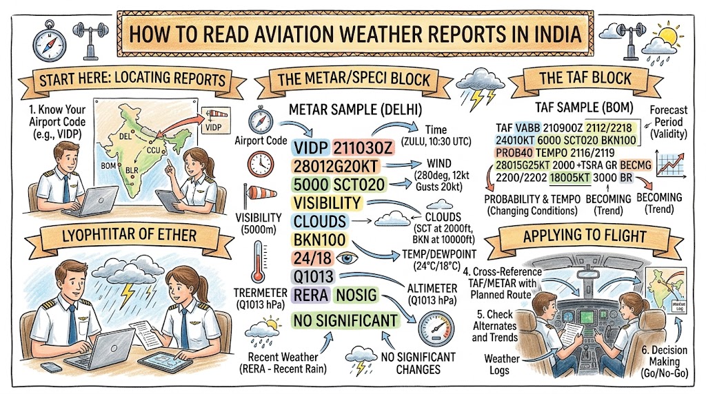
VIDP 150530Z 24008KT 4000 HZ SCT020 34/25 Q1004 NOSIG
may appear difficult to understand. However, each group follows a standard order and communicates specific information about the airport weather.
Learning to decode aviation weather reports is essential for every Indian student pilot. Weather affects aircraft performance, visibility, navigation, take-off, landing, fuel planning, route selection, and the final decision to fly.
The India Meteorological Department provides aviation observations, forecasts, warnings, and briefing services for flight operations in India. Routine METAR reports are generally issued at half-hourly intervals in India, while SPECI reports may be issued when significant weather changes meet specified criteria.
This guide explains the most important aviation weather reports and teaches students how to read them step by step.
Why Student Pilots Must Understand Aviation Weather
Weather is one of the most important factors in flight safety.
A pilot must understand whether current and forecast conditions are suitable for:
- Take-off
- Circuit training
- Local flying
- Solo flying
- Cross-country navigation
- Instrument training
- Landing
- Returning to the home aerodrome
- Using an alternate aerodrome
Weather information also helps pilots identify hazards such as:
- Fog
- Haze
- Thunderstorms
- Heavy rain
- Strong winds
- Crosswinds
- Wind shear
- Low clouds
- Reduced visibility
- Dust storms
- Turbulence
- Tropical cyclones
A student should never depend only on how the sky looks from the flying school. Conditions may be very different at altitude, along the route, or at the destination.
Main Aviation Weather Reports Used in India
| Weather report | Main purpose | What it tells the pilot |
|---|---|---|
| METAR | Routine observation | Current weather at an aerodrome |
| SPECI | Special observation | Important weather change between routine reports |
| TAF | Aerodrome forecast | Expected conditions during a stated period |
| TREND | Short-period forecast | Expected short-term changes near an aerodrome |
| SIGMET | Significant weather warning | Hazardous weather affecting an FIR or route area |
| AIRMET | Weather advisory | Significant conditions mainly affecting lower-level operations |
| Aerodrome warning | Airport safety warning | Weather that may affect aircraft or ground operations |
| Wind-shear warning | Low-level wind hazard | Observed or expected wind shear near an aerodrome |
IMD aviation procedures include current observations, aerodrome forecasts, route and area forecasts, SIGMET information, aerodrome warnings, and wind-shear warnings as part of aviation meteorological services.
METAR Explained
METAR is a routine aviation weather observation for an aerodrome.
It provides the actual observed weather at the stated date and time. It is not a prediction.
A METAR commonly includes:
- Report type
- Aerodrome identifier
- Observation time
- Wind
- Visibility
- Runway visual range, when applicable
- Present weather
- Cloud
- Temperature
- Dew point
- QNH
- Recent or supplementary weather
- Short-term trend, when included
Simple METAR Reading Order
Use this sequence:
Airport → Time → Wind → Visibility → Weather → Cloud → Temperature → Pressure → Trend
Remembering this order makes long reports much easier to decode.
Training METAR Example
Consider this fictional training example:
METAR VIDP 150530Z 24008KT 4000 HZ SCT020 34/25 Q1004 NOSIG
This is only a learning example and not a live weather report.
Let us decode it group by group.
METAR
This identifies the message as a routine aerodrome weather report.
A special report would begin with SPECI instead.
VIDP
This is the four-letter ICAO location indicator for Indira Gandhi International Airport, Delhi.
Indian aerodromes use four-letter ICAO identifiers. Examples include:
- VIDP – Delhi
- VABB – Mumbai
- VOBL – Bengaluru
- VOMM – Chennai
- VECC – Kolkata
- VOHY – Hyderabad
- VIJP – Jaipur
- VAPO – Pune
The Airports Authority of India publishes official aerodrome identifiers and operational information through the Indian Aeronautical Information Publication.
150530Z
This is the observation date and time.
- 15 means the 15th day of the month.
- 0530 means 05:30.
- Z means Coordinated Universal Time, commonly called UTC or Zulu time.
India Standard Time is UTC plus 5 hours and 30 minutes.
Therefore:
05:30 UTC = 11:00 IST
Student pilots must be careful because Indian local time is not used in the coded report.
24008KT
This is the wind group.
- 240 means the wind is coming from 240 degrees.
- 08 means the speed is 8 knots.
- KT means knots.
The wind is therefore:
From 240 degrees at 8 knots
Wind direction always tells the pilot where the wind is coming from, not where it is going.
Gusting Wind Example
24008G18KT
This means:
- Wind from 240 degrees
- Average speed 8 knots
- Gusting to 18 knots
The gust value is important because it can affect aircraft control, approach speed, crosswind limits, and landing stability.
Variable Wind Example
VRB03KT
This means the wind direction is variable at 3 knots.
Calm Wind Example
00000KT
This indicates calm wind.
Changing Direction Example
180V240
This means the wind direction is varying between 180 and 240 degrees.
This group normally follows the main wind group.
4000
This is the prevailing visibility.
The value is normally stated in metres.
4000 means 4,000 metres or 4 kilometres.
Other examples include:
- 0800 – 800 metres
- 3000 – 3 kilometres
- 6000 – 6 kilometres
- 9999 – 10 kilometres or more
A common beginner mistake is reading 9999 as 9,999 metres. Operationally, it means visibility is at least 10 kilometres.
HZ
HZ means haze.
Haze is especially important for Indian pilots because it may affect visibility during winter, summer, dry weather, and periods of air pollution.
Haze can make it difficult to:
- Identify landmarks
- See nearby traffic
- Recognize the horizon
- Locate the runway
- Judge distance
- Maintain visual navigation
SCT020
This is the cloud group.
- SCT means scattered cloud.
- 020 means the cloud base is 2,000 feet above the aerodrome.
Cloud height numbers are stated in hundreds of feet.
Therefore:
- 005 means 500 feet
- 010 means 1,000 feet
- 020 means 2,000 feet
- 100 means 10,000 feet
Cloud Amount Codes
| Code | Meaning | Approximate sky coverage |
|---|---|---|
| FEW | Few clouds | 1–2 oktas |
| SCT | Scattered clouds | 3–4 oktas |
| BKN | Broken clouds | 5–7 oktas |
| OVC | Overcast | 8 oktas |
| NSC | No significant cloud | No significant operational cloud reported |
| VV | Vertical visibility | Sky obscured and vertical visibility reported |
Cloud Examples
FEW015
Few clouds at 1,500 feet.
SCT020
Scattered clouds at 2,000 feet.
BKN025
Broken clouds at 2,500 feet.
OVC008
Overcast cloud at 800 feet.
VV003
The sky is obscured, and vertical visibility is 300 feet.
CB and TCU
Two cloud types require special attention:
- CB – cumulonimbus
- TCU – towering cumulus
Example:
FEW025CB
This means a few cumulonimbus clouds with bases at 2,500 feet.
Cumulonimbus clouds may be associated with:
- Thunderstorms
- Lightning
- Hail
- Severe turbulence
- Heavy rain
- Wind shear
- Strong downdrafts
- Microbursts
Student pilots should treat CB and TCU information seriously.
34/25
This is the temperature and dew-point group.
- 34 is the air temperature: 34°C.
- 25 is the dew point: 25°C.
The difference between temperature and dew point is called the dew-point spread.
A small spread may indicate an increased possibility of:
- Mist
- Fog
- Low cloud
- High humidity
- Reduced visibility
However, students should not make a flight decision using the dew-point spread alone. Wind, cloud, moisture, terrain, time of day, and forecast trends must also be considered.
Negative Temperature
The letter M means minus.
Example:
M02/M06
This means:
- Temperature: minus 2°C
- Dew point: minus 6°C
Q1004
This is the QNH group.
- Q identifies QNH.
- 1004 means 1004 hectopascals.
When the correct QNH is set on the altimeter while the aircraft is on the aerodrome, the instrument should indicate approximately the aerodrome elevation above mean sea level.
Indian altimeter-setting procedures use QNH information supplied through meteorological and air traffic services.
Students must confirm:
- The correct QNH
- The correct altimeter setting
- The expected aerodrome elevation indication
- Any difference between local QNH and regional pressure information
Incorrect pressure settings can create dangerous altitude errors.
NOSIG
NOSIG means no significant change is expected during the applicable short trend period.
It does not mean that the weather will remain completely unchanged.
Small changes may still occur. NOSIG means no operationally significant change is expected according to the applicable trend criteria.
Complete Decoding of the Example
METAR VIDP 150530Z 24008KT 4000 HZ SCT020 34/25 Q1004 NOSIG
The complete meaning is:
A routine weather observation for Delhi on the 15th day of the month at 05:30 UTC. Wind is from 240 degrees at 8 knots. Visibility is 4 kilometres in haze. Scattered clouds are present at 2,000 feet. Temperature is 34°C, dew point is 25°C, and QNH is 1004 hPa. No significant short-term change is expected.
Common Present Weather Codes
Precipitation Codes
| Code | Meaning |
|---|---|
| RA | Rain |
| DZ | Drizzle |
| SN | Snow |
| SH | Showers |
| TS | Thunderstorm |
| GR | Hail |
| GS | Small hail or snow pellets |
Visibility and Obscuration Codes
| Code | Meaning |
|---|---|
| BR | Mist |
| FG | Fog |
| HZ | Haze |
| FU | Smoke |
| DU | Widespread dust |
| SA | Sand |
| VA | Volcanic ash |
Other Important Codes
| Code | Meaning |
|---|---|
| SQ | Squall |
| FC | Funnel cloud or tornado/waterspout |
| DS | Dust storm |
| SS | Sandstorm |
| FZ | Freezing |
| BL | Blowing |
| DR | Low drifting |
| MI | Shallow |
| BC | Patches |
| PR | Partial |
| VC | In the vicinity |
Weather Intensity Symbols
A minus or plus sign may be added before weather codes.
- – means light.
- No sign normally means moderate.
- + means heavy.
Examples:
- -RA – light rain
- RA – moderate rain
- +RA – heavy rain
- -TSRA – thunderstorm with light rain
- +TSRA – thunderstorm with heavy rain
- VCFG – fog in the vicinity
- VCTS – thunderstorm in the vicinity
Runway Visual Range
Runway visual range, or RVR, may be included when visibility near a runway becomes operationally important.
Example:
R28/1200
This means:
- Runway 28
- Runway visual range of 1,200 metres
Possible trend letters include:
- U – increasing
- D – decreasing
- N – no distinct change
Example:
R28/0800D
This indicates an RVR of 800 metres on Runway 28 with a decreasing tendency.
Student pilots should not treat RVR as the same as general visibility. RVR specifically represents how far a pilot may see along the runway environment under the measured conditions.
CAVOK
CAVOK means “ceiling and visibility okay.”
It may replace the visibility, significant-weather, and cloud groups when specified aviation conditions are satisfied.
CAVOK generally indicates:
- Visibility of 10 kilometres or more
- No significant weather
- No operationally significant low cloud
- No cumulonimbus or towering cumulus requiring reporting
CAVOK does not necessarily mean there are no clouds anywhere in the sky.
SPECI Explained
SPECI is a special aerodrome weather report.
It uses the same coding format as METAR, but it may be issued between routine observations when specified weather conditions change significantly.
A SPECI may be associated with changes involving:
- Wind
- Visibility
- Runway visual range
- Thunderstorms
- Heavy precipitation
- Fog
- Low cloud
- Squalls
- Dust storms
- Sandstorms
- Wind shear
- Other operationally significant conditions
Because SPECI represents a meaningful change, students should check whether a newer SPECI has replaced the conditions shown in an earlier METAR.
TAF Explained
TAF means Terminal Aerodrome Forecast.
A TAF describes expected weather conditions at an aerodrome during a stated validity period.
Unlike METAR, which describes observed conditions, TAF describes forecast conditions.
Basic TAF Structure
A TAF commonly includes:
- TAF identifier
- Aerodrome identifier
- Issue time
- Validity period
- Forecast wind
- Forecast visibility
- Forecast weather
- Forecast cloud
- Expected change groups
Training TAF Example
Consider this fictional example:
TAF VIDP 150500Z 1506/1612 24010KT 5000 HZ SCT020 TEMPO 1508/1512 3000 TSRA SCT015 FEW030CB BECMG 1516/1518 27006KT 6000
This is only a training example.
TAF
This identifies the report as a Terminal Aerodrome Forecast.
VIDP
The forecast is for Delhi.
150500Z
The TAF was issued on the 15th at 05:00 UTC.
1506/1612
This is the forecast validity period.
- It begins on the 15th at 06:00 UTC.
- It ends on the 16th at 12:00 UTC.
Always identify both the issue time and the validity period. A TAF may have been issued earlier but still remain valid.
24010KT 5000 HZ SCT020
These are the main forecast conditions:
- Wind from 240 degrees at 10 knots
- Visibility 5 kilometres
- Haze
- Scattered clouds at 2,000 feet
These conditions form the forecast baseline until a change group applies.
TEMPO 1508/1512
TEMPO means temporary fluctuations are expected.
In this example, temporary conditions are expected between:
- The 15th at 08:00 UTC
- The 15th at 12:00 UTC
The temporary conditions are:
3000 TSRA SCT015 FEW030CB
This means:
- Visibility temporarily 3 kilometres
- Thunderstorm with rain
- Scattered cloud at 1,500 feet
- Few cumulonimbus clouds at 3,000 feet
TEMPO does not mean that the stated weather will exist continuously throughout the entire period. It indicates temporary periods of those conditions.
BECMG 1516/1518
BECMG means conditions are expected to gradually become different during the stated period.
In this example, between 16:00 and 18:00 UTC on the 15th, conditions are forecast to become:
- Wind from 270 degrees at 6 knots
- Visibility 6 kilometres
After the change is completed, the new conditions become the expected baseline.
Important TAF Change Groups
FM
FM means “from.”
Example:
FM151400
This means a new set of forecast conditions begins from the 15th at 14:00 UTC.
An FM group normally introduces a relatively complete change in the forecast conditions.
BECMG
BECMG means conditions are gradually changing during a stated time period.
Example:
BECMG 1516/1518
The transition is expected sometime between 16:00 and 18:00 UTC.
TEMPO
TEMPO indicates temporary fluctuations.
Example:
TEMPO 1508/1512 2000 TSRA
Temporary visibility of 2 kilometres in thunderstorm rain is possible during that period.
PROB30 and PROB40
These groups indicate a probability of specified weather.
- PROB30 – 30% probability
- PROB40 – 40% probability
Example:
PROB30 TEMPO 1510/1514 TSRA
There is a 30% probability of temporary thunderstorm rain between the stated times.
Students should not ignore a PROB30 hazard merely because the probability is below 50%. The operational importance depends on the severity of the possible condition, aircraft capability, route, pilot qualification, and available alternatives.
TREND Forecast
A TREND forecast is a short-period forecast that may be attached to a METAR or SPECI.
Common trend terms include:
- NOSIG
- BECMG
- TEMPO
A TREND is useful for arrival and departure planning, but it does not replace the full TAF.
SIGMET Explained
SIGMET stands for Significant Meteorological Information.
It warns pilots about specified weather phenomena that may affect aircraft safety within a Flight Information Region.
SIGMET information may cover hazards such as:
- Thunderstorms
- Severe turbulence
- Severe icing
- Tropical cyclones
- Volcanic ash
- Dust storms
- Sandstorms
- Mountain waves
- Radioactive cloud, where applicable
Unlike METAR and TAF, a SIGMET is not limited to one airport.
A pilot planning a cross-country flight must check for SIGMET information affecting:
- Departure area
- Planned route
- Destination
- Alternate aerodrome
- Nearby diversion routes
Aerodrome and Wind-Shear Warnings
Aerodrome warnings advise operators about weather that may affect aircraft on the ground or aerodrome facilities.
These may involve:
- Strong surface wind
- Squalls
- Thunderstorms
- Hail
- Frost
- Tropical cyclones
- Heavy precipitation
- Dust or sandstorms
Wind-shear warnings indicate observed or expected wind shear near the airport.
Wind shear is especially dangerous during:
- Take-off
- Initial climb
- Final approach
- Landing
Student pilots should never dismiss a wind-shear warning simply because the surface wind appears manageable.
Reading Weather Reports in the Correct Order
Use the following method every time.
Step 1: Confirm the Aerodrome
Check the four-letter ICAO code.
Do not accidentally read the weather for another airport with a similar name or nearby location.
Step 2: Check the Report Time
Confirm:
- Date
- UTC time
- Conversion to IST
- Age of the report
An old report may not represent current conditions.
Step 3: Read the Wind
Identify:
- Direction
- Speed
- Gusts
- Variation
- Crosswind component
- Tailwind possibility
Compare the wind with the runway direction and student operating limits.
Step 4: Check Visibility and RVR
Determine whether visibility is suitable for:
- The planned operation
- Student qualification
- School limits
- Route conditions
- Safe return
Step 5: Identify Present Weather
Look for fog, mist, haze, rain, thunderstorms, dust, smoke, or other significant conditions.
Step 6: Examine Cloud
Check:
- Cloud amount
- Cloud base
- Broken or overcast layers
- Cumulonimbus
- Towering cumulus
- Vertical visibility
Step 7: Compare Temperature and Dew Point
A narrowing spread may suggest increasing moisture and possible mist, fog, or low cloud development.
Step 8: Confirm QNH
Ensure that the altimeter setting is current and correctly entered.
Step 9: Read the Trend or TAF
Do not make a decision using only the present weather.
Check whether conditions are expected to improve, deteriorate, or fluctuate.
Step 10: Check Warnings
Review SIGMET, aerodrome warnings, wind-shear information, and other significant-weather products relevant to the flight.
Common Mistakes Made by Student Pilots
Confusing METAR With TAF
METAR describes observed weather. TAF describes forecast weather.
Reading UTC as Indian Time
A report showing 0600Z does not mean 6:00 AM IST. It means 11:30 AM IST.
Reading Wind Direction Incorrectly
Wind direction indicates where the wind is coming from.
Misreading Cloud Height
BKN020 means broken cloud at 2,000 feet, not 20,000 feet.
Ignoring the Gust Value
A wind of 10 knots gusting to 25 knots must not be treated as a simple 10-knot wind.
Treating 9999 as Unlimited Visibility
It means visibility is 10 kilometres or more, not unlimited.
Ignoring CB or TCU
Even a small reported amount of cumulonimbus or towering cumulus deserves careful attention.
Treating TAF Timing as Exact
Forecast transitions may occur within the stated time window rather than at one precise minute.
Looking at Only One Aerodrome
Cross-country planning requires weather information for the route, destination, alternate, and possible diversion points.
Depending Only on an Unofficial App
Apps may be useful for study and awareness, but operational decisions should be based on approved, current information accepted by the flying school, instructor, operator, and relevant authorities.
Practical Weather-Briefing Checklist
Before flight, confirm that you have reviewed:
- Latest METAR
- Any newer SPECI
- Valid TAF
- TREND forecast
- SIGMET information
- Wind-shear warning
- Aerodrome warning
- Route weather
- Destination weather
- Alternate weather
- Relevant radar or satellite information
- Wind at planned altitude
- Expected visibility
- Cloud base
- Thunderstorm risk
- Fuel required for weather deviations
- Current school and instructor limits
Questions a Student Should Ask
Before accepting a flight, ask:
- Is the report current?
- Is the weather improving or deteriorating?
- Does the visibility meet the required limits?
- Is the cloud base suitable for the exercise?
- Is the crosswind within the student limit?
- Are gusts significant?
- Is there any CB, TCU, TS, or wind-shear warning?
- Could fog or haze develop before return?
- Is an alternate aerodrome available?
- Is enough fuel available for delay or diversion?
- Am I comfortable flying in these conditions?
Key Takeaways
- METAR reports observed aerodrome weather.
- SPECI reports significant weather changes between routine observations.
- TAF provides forecast aerodrome conditions.
- SIGMET warns about hazardous weather affecting a wider area or route.
- Aviation report times are normally written in UTC.
- Wind direction shows where the wind is coming from.
- Visibility is generally reported in metres.
- Cloud heights are coded in hundreds of feet.
- Temperature and dew point help pilots assess atmospheric moisture.
- QNH is used for altimeter setting.
- CB, TCU, thunderstorms, wind shear, and severe visibility reduction require special attention.
- A single METAR is never a complete weather briefing.
Frequently Asked Questions
What is a METAR?
A METAR is a routine coded report of observed weather conditions at an aerodrome.
What is the difference between METAR and SPECI?
METAR is issued routinely, while SPECI is issued when specified significant weather changes occur between routine observations.
What is a TAF?
A TAF is a coded forecast of expected weather conditions at an aerodrome during a stated validity period.
What does Z mean in a weather report?
Z means Zulu time, which is another name for UTC.
How do Indian pilots convert UTC into IST?
Add 5 hours and 30 minutes to UTC. Remember that the date may also change when converting late-evening UTC times.
What does 9999 mean in METAR?
It means prevailing visibility is 10 kilometres or more.
What does BKN020 mean?
It means broken cloud with a base at 2,000 feet above the aerodrome.
What does Q1013 mean?
It means the reported QNH is 1013 hectopascals.
What does TEMPO mean in a TAF?
TEMPO means temporary fluctuations from the main forecast conditions are expected during the stated period.
What does NOSIG mean?
NOSIG means no significant change is expected during the applicable short trend period.
What is the importance of SIGMET?
SIGMET warns pilots about specified hazardous weather that may affect safe flight within a wider airspace area.
Can a student pilot make a flight decision using only METAR?
No. The student should also check the TAF, route weather, warnings, destination, alternate conditions, fuel requirements, school procedures, and instructor guidance.
Conclusion
Reading aviation weather reports becomes easier when every code is interpreted in the correct order. Indian student pilots should practise decoding METAR, SPECI, TAF, TREND, and SIGMET information regularly. The final flight decision must combine current observations, forecasts, warnings, aircraft limitations, school procedures, personal limits, and instructor guidance.

