
Introduction
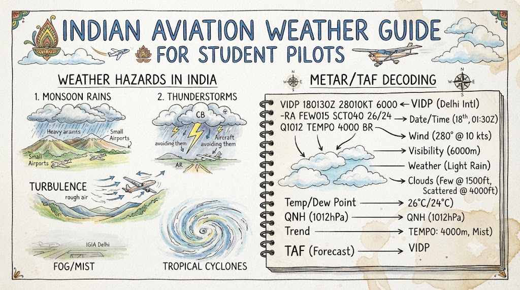
Weather knowledge is one of the most important parts of becoming a safe and responsible pilot. Student pilots training in India may experience monsoon rain, thunderstorms, winter fog, summer heat, haze, strong winds, dust, mountain weather and rapidly changing visibility. These conditions can affect aircraft performance, training schedules and flight safety. This Indian aviation weather guide from Pilotsindia.com explains the main weather concepts, reports, hazards and planning practices that every student pilot should understand before and during flight training.
Understanding Aviation Weather
Aviation weather is weather information prepared and presented specifically for pilots, flight dispatchers, air traffic services and other aviation professionals.
A general weather application may show rain, temperature and wind for a city. Aviation weather information provides additional operational details such as:
- Surface wind direction and speed
- Visibility
- Runway visual range
- Cloud amount and cloud base
- Thunderstorms and cumulonimbus clouds
- Atmospheric pressure
- Temperature and dew point
- Significant weather warnings
- Aerodrome forecasts
- Winds and temperatures at different altitudes
The India Meteorological Department is responsible for providing meteorological support to aviation in India. Its aviation services include current observations, forecasts, warnings and the distribution of weather products in approved aviation formats.
Weather can influence almost every stage of a flight, including:
- Take-off and landing performance
- Climb capability
- Navigation and route selection
- Fuel calculations
- Visual references
- Turbulence exposure
- Alternate aerodrome planning
- Training area availability
- Diversion decisions
- Overall pilot workload
A student pilot must therefore learn more than weather definitions. The real objective is to connect weather information with safe operational decisions.
Importance of Weather Training for Student Pilots
Aviation meteorology is not only an examination subject. It is a practical skill that must be applied before every flight.
Student pilots should be able to:
- Recognise dangerous weather patterns
- Decode basic aviation weather reports
- Compare reported conditions with forecasts
- Identify improving or deteriorating trends
- Understand aircraft performance in heat and low pressure
- Discuss weather risks with an instructor
- Consider suitable alternates
- Make conservative go or no-go decisions
The published DGCA aviation meteorology syllabus covers the atmosphere, temperature, pressure, wind, clouds, fog, precipitation, air masses, pressure systems, Indian climatology, flight hazards and meteorological information used for flight planning.
Passing a meteorology examination shows theoretical knowledge. Safe flying requires the student to use that knowledge under real operational conditions.
Major Weather Systems Affecting Indian Aviation
India has a wide geographical area with mountains, plains, deserts, coastlines, plateaus, islands and tropical regions. As a result, pilots may encounter very different weather conditions across the country.
Southwest Monsoon
The southwest monsoon is generally treated by IMD as the June-to-September rainfall season. It can bring widespread rain, deep cloud layers, low visibility, thunderstorms, strong winds and rapidly changing aerodrome conditions.
For student pilots, possible effects include:
- Cancellation or delay of visual training flights
- Reduced cloud bases
- Poor horizontal visibility
- Wet or contaminated runways
- Strong crosswinds and gusts
- Embedded thunderstorms
- Difficulty identifying safe visual routes
- Limited access to training areas
Monsoon conditions are not identical every day or in every region. Pilots must use current observations, forecasts and warnings rather than relying on seasonal assumptions.
Northeast Monsoon
IMD refers to October through December as the northeast monsoon period. It is particularly important for parts of southeastern peninsular India and can be associated with heavy rain, coastal weather and cyclonic activity.
Flying schools in affected areas may experience:
- Prolonged rain
- Low cloud
- Coastal thunderstorms
- Strong surface winds
- Water accumulation on runways
- Rapid changes in visibility
Pre-Monsoon Thunderstorms
Hot conditions combined with moisture and atmospheric instability can produce strong convective activity before the main monsoon season.
These storms may develop quickly and produce:
- Lightning
- Hail
- Heavy rain
- Squalls
- Severe turbulence
- Strong updrafts and downdrafts
- Wind shear
- Sudden visibility reduction
A clear morning does not guarantee safe weather later in the day. Students should review forecast development and not depend only on the first observation of the morning.
Western Disturbances
Western disturbances influence northern and northwestern India, particularly during winter and the transitional months. They may produce cloud, rain, snow, thunderstorms and changing winds.
In northern training areas, their effects can include:
- Low cloud
- Reduced visibility
- Rain or snow
- Mountain obscuration
- Changes in pressure
- Strong upper winds
- Turbulence around terrain
Tropical Cyclones
Cyclonic systems over the Bay of Bengal and Arabian Sea can affect coastal aerodromes and large inland areas.
Possible aviation effects include:
- Very strong winds
- Heavy rainfall
- Widespread cloud
- Severe turbulence
- Low pressure
- Airport closure or restricted operations
- Runway flooding
- Airspace and route disruption
IMD’s Tropical Cyclone Advisory Centre in New Delhi monitors tropical cyclones in its area of responsibility and supplies advisory information to meteorological watch offices.
Winter Fog
Fog is a major operational concern in parts of northern India during winter. It can reduce visibility significantly and disturb airport, road and rail operations. IMD routinely issues warnings when dense fog is expected to affect northern regions.
For student pilots, fog may:
- Prevent VFR departures
- Delay the beginning of training
- Hide terrain and obstacles
- Reduce runway visibility
- Cause diversions
- Create pressure to rush when visibility starts improving
Summer Heat
High temperatures are common at many Indian aerodromes during summer. Hot air is less dense than cool air, which can reduce aircraft and engine performance.
Students should carefully check:
- Aircraft performance charts
- Take-off distance
- Rate of climb
- Density altitude
- Runway length
- Aircraft weight
- Wind conditions
- Instructor and school limitations
Indian Weather Conditions by Season
| Season | Common Conditions | Possible Aviation Effects | Student Pilot Precautions |
|---|---|---|---|
| Winter | Fog, haze, low temperatures, western disturbances and strong upper winds | Poor visibility, delays, low cloud and changing winds | Check visibility trends, temperature–dew point spread, forecasts and alternate options |
| Pre-monsoon summer | High temperatures, dust, haze, gusty winds and thunderstorms | Reduced performance, turbulence, wind shear and sudden visibility loss | Calculate performance carefully and monitor convective development |
| Southwest monsoon | Heavy rain, low cloud, thunderstorms, gusts and wet runways | Training cancellations, poor visibility, diversions and difficult landings | Review METAR, TAF, SIGMET, radar and runway conditions |
| Post-monsoon | Retreating rain, thunderstorms and possible cyclonic systems | Rapid coastal weather changes and operational disruption | Monitor official warnings and maintain flexible planning |
| Northeast monsoon | Rain, low cloud, coastal thunderstorms and cyclonic weather in affected regions | Reduced visibility, strong winds and aerodrome disruption | Use current official weather information and instructor-approved limits |
Seasonal patterns provide background knowledge, but they must never replace a current flight-specific weather briefing.
Regional Aviation Weather Across India
Northern Plains
Northern plains may experience winter fog, haze, dust, summer thunderstorms, hot surface temperatures and weather associated with western disturbances.
Students should pay particular attention to:
- Morning visibility
- Temperature and dew point
- Thunderstorm forecasts
- Surface wind changes
- Dust or haze
- Weather trends during the planned flight period
Himalayan and Mountainous Regions
Mountain weather can change quickly. Terrain can influence wind, cloud formation and precipitation.
Major concerns include:
- Mountain waves
- Rotor turbulence
- Strong downdrafts
- Valley winds
- Cloud-covered terrain
- Restricted visibility
- Limited diversion routes
- Rapidly rising cloud
- Icing at suitable temperatures
Mountain flying requires specialised training, suitable aircraft, detailed route planning and conservative judgement.
Western Desert Regions
Desert and semi-arid regions may experience high temperatures, dust, turbulence and strong surface heating.
Possible hazards include:
- Reduced visibility in dust
- High density altitude
- Strong thermal turbulence
- Gusty winds
- Dust storms
- Increased take-off distance
Coastal Areas
Coastal weather is affected by humidity, sea breezes, land breezes, thunderstorms, rain and cyclonic systems.
Students may notice significant wind changes during the day as the land and sea heat at different rates. These wind changes can affect runway selection, circuits and crosswind conditions.
Central India
Central regions may experience strong summer heating, convective thunderstorms and widespread monsoon rainfall.
Weather can develop rapidly during the afternoon, so morning conditions must not be assumed to remain unchanged.
Northeastern India
Northeastern India receives substantial rainfall and contains complex terrain. Pilots may face:
- Frequent cloud
- Heavy rain
- reduced visibility
- Terrain obscuration
- Thunderstorms
- Limited visual routes
Southern Peninsula
Southern India can be influenced by both the southwest and northeast monsoon systems. Coastal and inland conditions may vary significantly because of terrain, moisture and local wind patterns.
Island Territories
Island flying can involve:
- Rapid maritime weather changes
- High humidity
- Showers and thunderstorms
- Strong winds
- Limited alternates
- Long overwater sectors
Careful fuel, alternate and weather planning is essential.
Official Sources of Aviation Weather in India
Students should learn to obtain weather information from recognised aviation sources rather than depending only on consumer weather applications.
The main sources include:
METAR and SPECI
A METAR is a routine coded aerodrome weather report. A SPECI is a special report issued when specified significant changes or conditions occur between routine reports.
IMD states that METARs in India are issued at half-hourly intervals, while a SPECI may be issued when relevant criteria are met.
Terminal Aerodrome Forecast
A TAF provides the expected meteorological conditions at an aerodrome during a specified period.
IMD states that Indian aerodrome meteorological offices issue TAFs for their aerodromes and associated stations. Its published service information describes 30-hour TAFs for international flights and 9-hour TAFs for domestic flights.
TREND Forecast
A TREND forecast is a short-period landing forecast that may be attached to a weather report. In India, the published validity period is two hours from the report to which it is attached.
SIGMET
A SIGMET provides information about specified en-route weather phenomena that may affect aircraft safety within a flight information region.
Indian Meteorological Watch Offices at Chennai, Delhi, Kolkata and Mumbai issue SIGMET information for their respective FIR responsibilities.
Aerodrome and Wind-Shear Warnings
Aerodrome warnings concern weather that may adversely affect aircraft on the ground, aerodrome facilities or services.
Wind-shear warnings provide information about wind shear that could affect aircraft during approach, take-off, circling, landing roll or take-off run.
Weather Radar and Satellite Images
Radar can help show precipitation intensity, movement and convective development. Satellite images provide a wider view of cloud patterns and major weather systems.
These images require correct interpretation. A student should review them with an instructor rather than making independent operational decisions from images alone.
Significant Weather Charts
Significant weather charts can show forecast hazards such as thunderstorms, turbulence, icing and major cloud areas.
They should be considered together with:
- Current observations
- Aerodrome forecasts
- SIGMETs
- Upper-wind information
- Route forecasts
- Operational notices
ATIS
ATIS may include aerodrome weather and other operational information. India’s AIP material states that the latest aerodrome weather report and a two-hour trend forecast are included in ATIS broadcasts at specified major airports.
Online Briefing System
IMD maintains web-based aviation product delivery systems through meteorological offices in Delhi and Chennai. Registered or authorised users can obtain forecast products and pre-flight meteorological documentation through these systems.
A student pilot should obtain weather through the flying school’s approved briefing process and discuss the information with the assigned instructor.
METAR Guide for Student Pilots
A METAR describes observed weather at or near an aerodrome at a specific time.
A typical METAR may contain:
- Report type
- Aerodrome identifier
- Observation date and time
- Surface wind
- Visibility
- Runway visual range, when reported
- Present weather
- Cloud amount and height
- Temperature and dew point
- Pressure setting
- Supplementary or trend information
Educational METAR Example
METAR VOZZ 131000Z 24012G22KT 4000 TSRA SCT018CB BKN030 28/25 Q1004 NOSIG=
Important: VOZZ is a fictional aerodrome identifier. This example is for education only and must never be used for flight planning.
Line-by-Line Interpretation
METAR
This is a routine aerodrome weather report.
VOZZ
This is the fictional station identifier.
131000Z
The observation was made on the 13th day of the month at 1000 UTC.
24012G22KT
Wind is from 240 degrees at 12 knots, with gusts reaching 22 knots.
4000
Reported prevailing visibility is 4,000 metres.
TSRA
A thunderstorm with rain is reported.
SCT018CB
Scattered cumulonimbus cloud is reported with a cloud base at 1,800 feet above the aerodrome.
BKN030
Broken cloud is reported at 3,000 feet.
28/25
Temperature is 28°C and dew point is 25°C. The small difference suggests moist air, although pilots must evaluate the complete weather picture rather than one pair of numbers.
Q1004
The reported QNH is 1004 hPa.
NOSIG
No significant change is expected during the applicable short trend period.
The report shows several concerns: thunderstorms, gusty winds, restricted visibility and cumulonimbus cloud. A student pilot should not focus on only one group. The complete report must be considered with the TAF, SIGMET, radar, instructor guidance and school operating limits.
TAF Guide for Student Pilots
A TAF describes forecast conditions at an aerodrome during a stated validity period. Unlike a METAR, it does not report only the conditions observed at one moment.
Educational TAF Example
TAF VOZZ 130900Z 1312/1321 24012KT 6000 SCT020 BKN080
TEMPO 1313/1317 3000 TSRA SCT015CB
BECMG 1318/1320 27008KT 8000 NSW SCT025=
This is also a fictional example.
Line-by-Line Interpretation
TAF VOZZ
Aerodrome forecast for the fictional VOZZ station.
130900Z
The forecast was issued on the 13th at 0900 UTC.
1312/1321
The forecast is valid from 1200 UTC until 2100 UTC on the 13th.
24012KT
The forecast wind is from 240 degrees at 12 knots.
6000
Forecast visibility is 6,000 metres.
SCT020 BKN080
Scattered cloud is forecast at 2,000 feet and broken cloud at 8,000 feet.
TEMPO 1313/1317
Temporary conditions are expected between 1300 and 1700 UTC.
3000 TSRA SCT015CB
During the temporary period, visibility may reduce to 3,000 metres in thunderstorm rain, with scattered cumulonimbus cloud at 1,500 feet.
BECMG 1318/1320
A gradual change is forecast between 1800 and 2000 UTC.
27008KT 8000 NSW SCT025
Conditions are forecast to become wind from 270 degrees at 8 knots, visibility 8,000 metres, no significant weather and scattered cloud at 2,500 feet.
A TAF is a forecast, not a guarantee. Actual conditions may develop earlier, later or differently. Pilots must monitor amended forecasts, METARs, SPECIs and warnings.
Important Aviation Weather Codes
| Code | Meaning | Operational Importance |
|---|---|---|
| RA | Rain | May reduce visibility and affect runway condition |
| DZ | Drizzle | Can indicate low cloud and reduced visibility |
| TS | Thunderstorm | May involve turbulence, lightning, hail and wind shear |
| TSRA | Thunderstorm with rain | Indicates convective weather with precipitation |
| FG | Fog | Significant visibility restriction |
| BR | Mist | Reduced visibility from suspended water droplets |
| HZ | Haze | Reduced visibility from fine dry particles |
| FU | Smoke | Visibility reduction and possible air-quality concern |
| DU | Widespread dust | May reduce visibility |
| SQ | Squall | Sudden strong increase in wind speed |
| CB | Cumulonimbus | Severe convective weather may be present |
| TCU | Towering cumulus | Strong vertical cloud growth and possible storm development |
| FEW | Few clouds | One to two oktas of cloud coverage |
| SCT | Scattered clouds | Three to four oktas of cloud coverage |
| BKN | Broken clouds | Five to seven oktas; may form an operational ceiling |
| OVC | Overcast | Eight oktas of cloud |
| CAVOK | Prescribed visibility, cloud and significant-weather criteria are satisfied | Indicates generally favourable reported conditions but does not remove the need for full planning |
Students should use the approved aviation weather codebook and current training material to learn the full coding system.
Clouds and Their Importance in Flying
Clouds provide useful information about atmospheric moisture, stability and vertical movement.
Cumulus
Small cumulus clouds are commonly associated with rising air. Moderate development may produce bumps beneath or around the cloud.
Rapid vertical growth should be treated carefully because it may indicate increasing instability.
Towering Cumulus
Towering cumulus has strong vertical development and may grow into cumulonimbus.
It can be associated with:
- Strong updrafts
- Downdrafts
- Turbulence
- Heavy showers
- Developing lightning activity
Cumulonimbus
Cumulonimbus is a thunderstorm cloud and must be treated as a serious hazard.
It may contain:
- Severe turbulence
- Hail
- Lightning
- Icing
- Heavy precipitation
- Wind shear
- Strong vertical currents
Stratus
Stratus is a low, uniform cloud layer. It can produce low ceilings, drizzle and restricted visibility.
Low stratus may make visual flight training impossible even when surface visibility appears reasonable.
Stratocumulus
Stratocumulus occurs in layers or patches. It may be relatively benign, but widespread low stratocumulus can limit altitude and visual navigation options.
Altostratus and Nimbostratus
Altostratus forms a middle-level cloud sheet, while nimbostratus is associated with widespread precipitation.
These layers may cover large areas and create prolonged poor weather.
Cirrus
Cirrus is a high-level ice-crystal cloud. It usually does not create the same immediate low-level hazards as cumulonimbus, but it can provide clues about changing upper-level weather.
Thunderstorms and Cumulonimbus Hazards
Thunderstorms are among the most dangerous weather hazards for aircraft.
A thunderstorm may produce:
- Severe or extreme turbulence
- Strong updrafts and downdrafts
- Microbursts
- Wind shear
- Hail
- Lightning
- Heavy precipitation
- Rapid visibility loss
- Pressure changes
- Icing
- Static interference
The DGCA aviation meteorology syllabus specifically includes thunderstorm structure, squall lines, lightning, downbursts, radar and thunderstorm avoidance.
A student pilot must never assume that a small-looking storm is safe to approach. The correct response is based on avoidance, approved procedures, official weather information and instructor or pilot-in-command judgement.
Monsoon Flying Conditions
Monsoon weather may affect a training flight before departure, during the circuit or while the aircraft is in the training area.
Heavy Rain
Heavy rain can:
- Reduce forward visibility
- Hide terrain and other aircraft
- Affect runway braking
- Increase workload
- Make visual navigation difficult
- Obscure the runway during approach
Low Cloud
Low cloud may prevent a student from maintaining required visual conditions or safe terrain clearance.
Cloud base must be considered throughout the route, not only at the departure aerodrome.
Gusts and Crosswinds
Monsoon systems may produce variable winds and strong gusts. A reported mean wind may therefore not describe the maximum conditions a pilot will experience.
Students must compare conditions with:
- Aircraft limitations
- School operating limits
- Instructor limits
- Runway direction
- Personal training stage
Rapid Weather Changes
A monsoon shower may reduce visibility and cloud base within a short period. A route that was open during departure may no longer be suitable during the return.
Continuous weather monitoring and alternate planning are essential.
Fog, Mist, Haze and Reduced Visibility
These terms describe different atmospheric conditions, but all can interfere with visual flying.
Fog
Fog consists of water droplets near the surface and causes significant visibility reduction.
Mist
Mist also consists of water droplets but generally produces less severe visibility reduction than fog under the applicable reporting definitions.
Haze
Haze is caused mainly by fine dry particles and may create poor slant visibility even when reported horizontal visibility appears acceptable.
Smoke
Smoke may reduce visibility and hide landmarks, terrain or traffic.
Dust
Dust can create sudden or widespread visibility reduction, particularly in dry and windy regions.
Precipitation
Heavy rain can significantly reduce forward visibility, sometimes more than the pilot expects from the general aerodrome report.
A student should evaluate both reported visibility and the likely visibility along the route.
Wind and Its Effect on Flight
Wind affects take-off, landing, navigation, fuel use and passenger comfort.
Headwind
A headwind generally reduces groundspeed and may increase journey time and fuel requirement. During take-off and landing, it usually reduces the ground distance required compared with calm conditions, subject to aircraft performance data.
Tailwind
A tailwind increases groundspeed but may increase take-off and landing distance. Tailwind operations must remain within aircraft and operational limits.
Crosswind
A crosswind acts across the runway. Its effect depends on:
- Wind speed
- Wind direction
- Runway direction
- Gusts
- Aircraft type
- Pilot skill
- Runway condition
There is no single safe crosswind limit for all students or aircraft.
Gusts
Gusts are rapid changes in wind speed. They may cause airspeed fluctuations and increase control difficulty during take-off, approach and landing.
Wind Shear
Wind shear is a change in wind direction or speed over a relatively short distance.
It is especially dangerous close to the ground because the pilot has limited height and time to respond. IMD provides wind-shear warning services for relevant approach, departure and runway areas.
Sea and Land Breezes
Coastal heating can create local wind changes. Runway wind may therefore change between morning, afternoon and evening.
Mountain and Valley Winds
Airflow over and through terrain can create:
- Strong downdrafts
- Turbulence
- Rotor activity
- Rapid wind-direction changes
- Dangerous conditions near ridges and passes
Temperature, Pressure and Aircraft Performance
Aircraft performance depends partly on air density.
Air density generally decreases when:
- Temperature increases
- Pressure decreases
- Altitude increases
Lower air density may cause:
- Longer take-off distance
- Reduced climb performance
- Lower engine performance in many aircraft
- Reduced propeller efficiency
- Reduced aerodynamic performance for a given true airspeed
The published DGCA syllabus includes atmospheric density, pressure, temperature, International Standard Atmosphere, pressure altitude and altimetry.
Density Altitude
Density altitude is pressure altitude corrected for non-standard temperature.
A high-density-altitude day can make an aerodrome behave as though it were located at a higher altitude. This is especially important when an aircraft is:
- Heavily loaded
- Operating from a short runway
- Taking off in high temperatures
- Operating from an elevated aerodrome
- Flying with little wind
Students must use the approved aircraft flight manual or pilot operating handbook rather than estimating performance informally.
Atmospheric Pressure and Altimeter Settings
QNH
When the altimeter is set to QNH, it indicates altitude related to mean sea level within the limitations of the pressure system and instrument.
QFE
QFE is a pressure setting associated with a specific aerodrome reference level. When used appropriately, the altimeter may indicate height relative to that reference.
Standard Pressure
Standard pressure is 1013.25 hPa. It is used for flight-level operations according to applicable procedures.
Transition Altitude and Transition Level
The transition altitude and transition level separate operations using altitude references from operations using flight levels.
Students should not rely on memorised assumptions. They must follow:
- Current Indian procedures
- ATC instructions
- Aerodrome information
- Flight-school procedures
- Instructor guidance
An incorrect pressure setting can create a dangerous difference between indicated and actual vertical position.
Aircraft Icing
Structural icing can form when supercooled water droplets freeze on an aircraft surface.
It may:
- Change the aerofoil shape
- Increase drag
- Reduce lift
- Increase stall speed
- Add weight
- Reduce propeller efficiency
- Block or affect sensors
Other forms include:
- Carburettor icing
- Induction icing
- Instrument or probe icing
The DGCA meteorology syllabus includes icing conditions, types of ice accretion, hazards and avoidance.
A training aircraft that is not approved or equipped for icing conditions must not be intentionally flown into such conditions. Aircraft-specific manuals and approved procedures always take priority.
Turbulence and Wind Shear
Mechanical Turbulence
Mechanical turbulence develops when wind flows around buildings, trees, hills or other obstacles.
It may be stronger on the downwind side.
Thermal Turbulence
Strong surface heating creates rising bubbles of warm air. This can make low-level summer flying uncomfortable and demanding.
Convective Turbulence
Convective turbulence occurs around developing showers and thunderstorms. It can become severe.
Clear-Air Turbulence
Clear-air turbulence may occur without visible cloud, often near strong upper-level wind gradients or jet streams.
Mountain-Wave Turbulence
Stable airflow crossing mountain ranges can create waves, rotors and strong vertical air movement.
Microbursts
A microburst is a concentrated downdraft that spreads outward near the ground. It can produce rapid changes in headwind and tailwind during approach or departure.
Students should treat any wind-shear or microburst warning seriously.
Pre-Flight Weather Briefing Process
A useful student-pilot briefing sequence is:
- Review the overall weather pattern affecting the region.
- Read the latest departure METAR and any SPECI.
- Study the departure TAF.
- Check destination and alternate weather.
- Review SIGMET and relevant warnings.
- Examine weather radar and satellite information.
- Review cloud bases and visibility along the route.
- Check winds at the surface and planned altitude.
- Review temperature, pressure and density-altitude effects.
- Check runway condition and operational information.
- Compare the conditions with school and aircraft limits.
- Discuss the complete picture with the instructor.
- Plan diversion points and alternate aerodromes.
- Obtain updated weather immediately before departure.
- Continue monitoring weather during the flight.
The decision must not be based on a single METAR, weather application or visual observation outside the window.
Go or No-Go Decision-Making
A safe decision considers several factors together.
Legal and Operational Requirements
The weather must comply with:
- Applicable regulations
- Licence privileges
- Aircraft limitations
- Flight-school procedures
- Aerodrome restrictions
- Instructor requirements
Personal Minimums
Personal minimums should be more conservative than the minimum permitted conditions, especially during early training.
They may address:
- Visibility
- Cloud base
- Wind speed
- Crosswind
- Gust spread
- Thunderstorm distance
- Temperature
- Route complexity
Pilot Experience
A condition that is manageable for an experienced instructor may not be appropriate for a first-solo student.
Weather Trends
The current weather may meet a limit while the forecast indicates deterioration. A safe pilot considers what conditions may exist during the return, not only during departure.
Alternatives
A good plan identifies:
- Suitable alternate aerodromes
- Safe diversion routes
- Decision points
- Additional fuel needs
- Conditions requiring an early return
A cancelled flight is not a failure. It is often evidence of good judgement.
Common Weather Mistakes Made by Student Pilots
Checking Only the Departure Aerodrome
Weather may be suitable at the departure airport but poor in the training area or at the destination.
Depending on One Application
A consumer application is not a replacement for official aviation observations, forecasts and warnings.
Ignoring Forecast Changes
Students may focus on present conditions and overlook forecast deterioration.
Misreading UTC
Confusing local time with UTC can cause a student to use an incorrect report or validity period.
Looking Only at Visibility
Reasonable visibility does not make a flight safe when cloud base, thunderstorms, wind or turbulence are unsuitable.
Underestimating Cumulonimbus
A storm does not need to be directly over the aerodrome to create gusts, turbulence, lightning or wind shear.
Ignoring Dew Point
A narrowing temperature–dew point spread can support the possibility of cloud or fog formation, but it must be interpreted with the full weather situation.
Failing to Plan an Alternate
A pilot without a realistic alternate may continue toward worsening weather because no other plan has been prepared.
Continuing Because of Schedule Pressure
Training targets, examinations, costs and personal plans must never influence a pilot to accept unsafe weather.
Avoiding Questions
A student should ask the instructor whenever a report, forecast or code is unclear.
Student Pilot Weather Safety Checklist
Before departure, confirm that you have reviewed:
- Latest METAR and SPECI
- Current TAF
- Destination and alternate weather
- SIGMET information
- Thunderstorm activity
- Visibility
- Cloud base
- Wind direction and speed
- Gusts
- Crosswind component
- Temperature and pressure
- Density altitude
- Rain, fog, haze or dust
- Runway condition
- Fuel and alternate requirements
- Weather trend
- Instructor approval
- Aircraft and school limits
Practical Training Scenario
A student pilot is scheduled for an afternoon navigation exercise. The morning weather is warm with light wind and good visibility.
Before departure, the student reviews the latest TAF. It includes a temporary period of thunderstorm rain, lower visibility and cumulonimbus cloud during the planned return time.
The current METAR still looks acceptable, but weather radar shows convective development near the intended route. The wind has also become gusty.
The student discusses the information with the instructor. Together, they consider:
- Moving the flight to an earlier period
- Selecting a different training area
- Conducting a local exercise
- Delaying the flight
- Cancelling the exercise
They decide not to complete the planned navigation flight because the forecast return period carries greater risk.
This is good aeronautical decision-making. The student used the forecast, current observation, radar, route conditions and instructor experience instead of waiting for the weather to become unsafe.
Weather Knowledge for DGCA Examinations
Aviation meteorology preparation should cover both theory and practical interpretation.
Important study areas include:
- Composition and structure of the atmosphere
- Temperature and heat transfer
- Pressure and pressure systems
- Atmospheric stability
- Humidity and dew point
- Wind and local wind systems
- Clouds and precipitation
- Fog, mist and haze
- Air masses and fronts
- Monsoon and Indian climatology
- Tropical cyclones
- Thunderstorms
- Turbulence
- Wind shear
- Icing
- Mountain weather
- Aviation weather charts
- METAR, SPECI, TAF and SIGMET
- Weather information for flight planning
These subjects appear in the published DGCA aviation meteorology syllabus. Students should also check the latest examination notices, syllabus material and instructions on the official DGCA examination portal before preparing for an examination.
Recommended Study Approach
Build the Foundation
First learn:
- Pressure
- Temperature
- Density
- Humidity
- Stability
- Wind
- Cloud formation
Without these basics, weather codes become difficult to understand.
Practise METAR Every Day
Decode one or two reports daily. Identify:
- Wind
- Visibility
- Weather
- Cloud
- Temperature
- Dew point
- Pressure
- Trend
Compare METAR with TAF
Check whether the observed conditions match the forecast. This teaches how forecasts develop and where uncertainty exists.
Study Local Weather
Learn the common weather risks around your training aerodrome, such as:
- Morning fog
- Afternoon thunderstorms
- Sea-breeze changes
- Dust
- Monsoon showers
- Mountain winds
Connect Theory with Flying
Before each flight, ask:
- What weather system is influencing the area?
- What may change during the flight?
- Which condition creates the greatest risk?
- What is the alternate plan?
Maintain a Weather Notebook
Record:
- Important weather codes
- Daily reports
- Forecast versus actual conditions
- Instructor explanations
- Weather-related flight decisions
This turns theory into practical experience.
Frequently Asked Questions
1. Why is aviation weather important for student pilots?
Aviation weather directly affects aircraft performance, visibility, route safety, take-off, landing and pilot workload. Student pilots must understand weather so they can recognise hazards, discuss risks with instructors and make conservative decisions.
2. Where can pilots obtain official aviation weather in India?
IMD provides aviation weather observations, forecasts, warnings and briefing products through its aviation meteorological network and online briefing systems. Students should use the approved briefing process provided by their flying school.
3. What is the difference between a METAR and a TAF?
A METAR reports observed aerodrome weather at a specific time. A TAF describes forecast aerodrome conditions during a stated validity period. Both should be used together during flight planning.
4. How does the monsoon affect flight training?
Monsoon conditions may bring rain, low cloud, thunderstorms, gusts, poor visibility and wet runways. These conditions can delay, shorten or cancel VFR training flights.
5. Why are thunderstorms dangerous for aircraft?
Thunderstorms may contain severe turbulence, lightning, hail, icing, heavy rain, wind shear and powerful vertical currents. Avoidance and approved operational procedures are essential.
6. What is density altitude?
Density altitude represents the aircraft-performance effect of air density. High temperature, low pressure and elevation can increase density altitude, resulting in longer take-off distance and weaker climb performance.
7. Can a student pilot fly when haze is reported?
The decision depends on reported and actual visibility, route conditions, legal requirements, aircraft limitations, school procedures and instructor approval. Haze can make landmarks, terrain and traffic difficult to see even when basic visibility appears acceptable.
8. Why are training flights cancelled when the weather appears clear?
The current aerodrome weather may be acceptable while the forecast shows thunderstorms, fog, strong winds or lower cloud during the flight period. Weather in the training area may also be worse than conditions at the airport.
9. How should students prepare aviation meteorology for DGCA examinations?
Students should study the official syllabus, approved books, instructor notes, weather codes, charts and practical report interpretation. Daily METAR and TAF practice helps connect examination theory with real flying.
10. Who makes the final weather decision during a training flight?
Responsibility depends on the flight stage and operating arrangement. In dual training, the instructor or pilot in command makes the operational decision. A solo student must follow the authorisation, limitations and procedures established by the instructor and flying school.
Key Takeaways
- Use official aviation weather sources for every flight.
- Read METAR and TAF together.
- Check weather for the complete route and return period.
- Treat thunderstorms and cumulonimbus clouds as serious hazards.
- Consider monsoon rain, winter fog, summer heat and regional weather.
- Compare conditions with aircraft, school and personal limits.
- Prepare alternates before departure.
- Continue monitoring weather during flight.
- Ask the instructor whenever information is unclear.
- Never allow schedule or cost pressure to influence a safety decision.
Conclusion
Understanding Indian aviation weather is essential for every student pilot because conditions such as monsoon rain, thunderstorms, fog, haze, strong winds, mountain weather and high temperatures can directly affect flight safety and aircraft performance. Students should learn to interpret METARs, TAFs, SIGMETs, weather charts and official warnings while developing conservative decision-making habits. Every briefing should consider the departure, route, destination, alternates and expected weather trend. By combining theoretical study with instructor-led practical interpretation, aviation learners can build the judgement required for safe flying. Pilotsindia.com can support this learning journey by providing clear, beginner-friendly aviation education focused on responsible pilot development.

