
Introduction
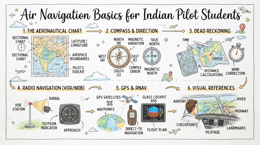
Air navigation is the process of planning, monitoring, and controlling an aircraft’s movement from one location to another.
For Indian pilot students, navigation training begins with simple exercises around the home aerodrome and gradually develops into longer cross-country flights. Students learn how to read aviation charts, calculate headings, correct for wind, estimate flight time, identify landmarks, manage fuel, and confirm the aircraft’s position throughout the flight.
Modern aircraft may use GPS and advanced navigation displays, but student pilots must still understand traditional navigation principles. Electronic systems can fail, provide incorrect information, or be used incorrectly. A pilot who understands basic navigation can recognize errors and continue making safe decisions.
This guide explains the essential air navigation concepts every Indian pilot student should understand.
Why Air Navigation Skills Matter
Navigation is more than following a line on a map.
Good navigation helps a pilot:
- Remain clear of restricted airspace
- Follow the planned route
- Avoid terrain and obstacles
- Estimate arrival time
- Monitor fuel consumption
- Identify suitable diversion aerodromes
- Maintain situational awareness
- Communicate accurate position reports
- Handle unexpected weather
- Return safely if equipment fails
Poor navigation can lead to airspace infringement, fuel shortage, loss of orientation, entry into unsuitable weather, or flight toward rising terrain.
Main Types of Air Navigation
Student pilots should understand several basic navigation methods.
| Navigation method | Basic principle | Common student use |
|---|---|---|
| Pilotage | Navigating by visual landmarks | Local and cross-country VFR flights |
| Dead reckoning | Using heading, speed, time, and wind | Planned navigation legs |
| Radio navigation | Using ground-based navigation aids | Position confirmation and tracking |
| Satellite navigation | Using GNSS or GPS information | Route guidance and position awareness |
| Inertial navigation | Using internal sensors | Mainly larger or advanced aircraft |
During basic flight training, pilotage and dead reckoning are especially important.
Pilotage
Pilotage means navigating by comparing visible features on the ground with features shown on an aviation chart.
Useful visual checkpoints may include:
- Major roads
- Railway lines
- Rivers
- Lakes
- Coastlines
- Towns
- Large industrial areas
- Airports
- Bridges
- Dams
- Mountain ridges
- Distinct terrain features
A good checkpoint should be:
- Easy to identify
- Clearly marked on the chart
- Visible from the planned altitude
- Large enough to recognize
- Different from nearby features
- Located close to the planned route
Small villages, minor roads, and similar-looking fields may be poor checkpoints because they are difficult to identify from the air.
Dead Reckoning
Dead reckoning is a method of estimating aircraft position using:
- Planned direction
- Wind
- Airspeed
- Groundspeed
- Time
- Distance
The pilot calculates where the aircraft should be after flying a specific heading for a specific time.
Dead reckoning is useful when landmarks are limited or when visibility makes visual identification difficult.
However, estimated position must be checked regularly against actual landmarks, navigation aids, or reliable aircraft systems.
Latitude and Longitude
Latitude and longitude are used to describe exact positions on Earth.
Latitude
Latitude measures distance north or south of the Equator.
Lines of latitude run east–west.
Examples include:
- 20° North
- 28° North
- 10° South
Longitude
Longitude measures distance east or west of the Prime Meridian.
Lines of longitude run north–south.
Examples include:
- 77° East
- 72° East
- 80° West
Indian locations normally use north latitude and east longitude.
Coordinates are often written in degrees, minutes, and sometimes seconds.
Students should learn how to:
- Locate coordinates on a chart
- Read coordinates correctly
- Record turning points
- Identify aerodrome locations
- Enter coordinates into approved navigation equipment
True North and Magnetic North
True north and magnetic north are not exactly the same.
True North
True north points toward the geographic North Pole.
Charts and route lines may be measured using true direction.
Magnetic North
Magnetic north is the direction indicated by a magnetic compass.
The difference between true north and magnetic north is called magnetic variation.
Variation changes with location and may also change gradually over time.
Students must use the current chart information and approved planning procedure when converting between true and magnetic directions.
Compass Deviation
A magnetic compass can be affected by magnetic fields inside the aircraft.
The difference between magnetic heading and compass heading is called deviation.
Deviation may result from:
- Electrical equipment
- Aircraft wiring
- Metal components
- Installed instruments
Aircraft normally have a compass correction card showing the heading correction required.
A basic conversion sequence is:
True direction → Magnetic direction → Compass direction
Students should follow the method taught by their flying school and instructor.
Heading, Track and Bearing
These three terms are often confused.
Heading
Heading is the direction in which the aircraft’s nose is pointing.
Track
Track is the actual path the aircraft follows over the ground.
Bearing
Bearing is the direction from one position to another object or location.
An aircraft may have a heading of 090 degrees while its track is 085 degrees because wind is pushing it sideways.
Understanding this difference is essential for wind correction.
Drift
Drift is the sideways movement of an aircraft caused by wind.
If wind comes from the left, it may push the aircraft to the right of the planned track.
To maintain the planned ground track, the pilot points the aircraft slightly into the wind.
The angle between the heading and track is called the drift angle or wind correction angle.
Simple Drift Example
Suppose the planned track is 090 degrees and wind from the north pushes the aircraft toward the south.
The pilot may need to fly a heading slightly north of east, such as 085 degrees, to maintain the planned 090-degree track.
The exact correction depends on:
- Wind direction
- Wind speed
- Aircraft true airspeed
- Planned track
Airspeed and Groundspeed
Airspeed is the aircraft’s speed relative to the surrounding air.
Groundspeed is the aircraft’s speed relative to the ground.
Wind creates the difference between them.
Headwind
A headwind reduces groundspeed.
This may result in:
- Longer flight time
- Greater fuel use
- Later arrival
- Need for additional reserve
Tailwind
A tailwind increases groundspeed.
This may result in:
- Shorter flight time
- Earlier arrival
- Faster movement between checkpoints
Crosswind
A crosswind mainly causes drift but may also affect groundspeed depending on its angle.
Students should use forecast wind to calculate the expected groundspeed before flight.
Speed, Distance and Time
Navigation planning depends heavily on the relationship between speed, distance, and time.
The basic formulas are:
Distance = Speed × Time
Time = Distance ÷ Speed
Speed = Distance ÷ Time
When speed is measured in knots and distance in nautical miles:
- 60 knots means 1 nautical mile per minute.
- 90 knots means 1.5 nautical miles per minute.
- 120 knots means 2 nautical miles per minute.
Example
An aircraft has a groundspeed of 90 knots and must travel 45 nautical miles.
Time required:
45 ÷ 90 = 0.5 hours
Therefore, the flight time is 30 minutes.
Students should practise these calculations until they can estimate them quickly.
Nautical Miles
Aviation distance is normally measured in nautical miles.
One nautical mile is based on the geometry of the Earth and is commonly used in air and sea navigation.
Students should avoid confusing:
- Nautical miles
- Statute miles
- Kilometres
Aviation charts, aircraft speeds, and flight plans normally use nautical miles and knots.
Aviation Chart Reading
An aviation chart provides information needed for safe route planning.
Depending on the chart type, it may show:
- Aerodromes
- Runways
- Controlled airspace
- Restricted areas
- Navigation aids
- Terrain elevation
- Obstacles
- Reporting points
- Air routes
- Frequencies
- Latitude and longitude
- Significant landmarks
- Airspace boundaries
Students must use current charts and approved aeronautical information.
An outdated chart may contain incorrect airspace boundaries, frequencies, restrictions, or navigation data.
Understanding Chart Scale
Chart scale shows the relationship between distance on the chart and actual distance on the ground.
A large-scale chart shows a smaller area in greater detail.
A small-scale chart shows a larger area with less detail.
Students should know how to:
- Measure route distance
- Select checkpoints
- Read terrain elevation
- Identify controlled airspace
- Locate restricted areas
- Mark turning points
The correct chart should match the type and area of the planned flight.
Controlled and Restricted Airspace
India has different categories of controlled, restricted, prohibited, and danger airspace.
Student pilots must identify airspace that may require:
- Air traffic control clearance
- Specific communication procedures
- Route restrictions
- Altitude restrictions
- Prior permission
- Complete avoidance
Entering controlled or restricted airspace without authorization can create serious safety and regulatory problems.
Before flight, check:
- Current chart
- Aeronautical information
- Notices affecting the route
- Air traffic control requirements
- Temporary restrictions
- Military activity
- Local flying-school procedures
Selecting a Route
A good training route should consider:
- Controlled airspace
- Terrain
- Weather
- Suitable checkpoints
- Emergency landing areas
- Restricted zones
- Navigation aids
- Fuel range
- Alternate aerodromes
- Communication coverage
The shortest route is not always the safest route.
A slightly longer route may be better if it provides:
- Clear landmarks
- Lower terrain
- More diversion options
- Better radio coverage
- Less restricted airspace
- Improved weather margins
Choosing Navigation Checkpoints
Checkpoints should be selected at useful intervals.
Good checkpoints may include:
- Major road intersections
- Large towns
- Rivers crossing highways
- Railway junctions
- Large lakes
- Distinct coastlines
- Airports
- Dams
- Isolated hills
Avoid relying on features that may be difficult to see, such as:
- Small roads
- Minor villages
- Temporary construction
- Small ponds
- Similar-looking fields
- Features hidden by haze
Each checkpoint should have an estimated time of arrival.
Navigation Log
A navigation log organizes the planned flight into separate legs.
A typical navigation log may include:
- Departure point
- Turning point
- Destination
- True track
- Magnetic variation
- Magnetic track
- Forecast wind
- Wind correction angle
- Heading
- Airspeed
- Groundspeed
- Distance
- Estimated time
- Fuel required
- Altitude
- Frequency
- Checkpoint notes
The exact format may differ between flying schools.
Students should prepare the navigation log carefully and understand every entry rather than copying numbers without explanation.
Estimated Time of Arrival
Estimated time of arrival, or ETA, is calculated using the departure time and estimated flight time.
During flight, the ETA should be updated when:
- Groundspeed differs from plan
- Wind changes
- The route changes
- Air traffic causes delay
- Weather requires deviation
- A checkpoint is reached early or late
An incorrect ETA may affect:
- Fuel planning
- Air traffic coordination
- Daylight limitations
- Alternate planning
- Search and rescue response
The One-in-Sixty Rule
The one-in-sixty rule is a simple mental-navigation technique.
It states that if an aircraft is one mile off track after travelling sixty miles, the track error is approximately one degree.
The rule can be used to estimate:
- Track error
- Required heading correction
- Distance off track
- Closing angle
Simple Example
If an aircraft is 2 nautical miles right of track after 30 nautical miles:
Track error ≈ 2 ÷ 30 × 60
The error is approximately 4 degrees.
A pilot may need a correction to regain the planned track and then a smaller correction to continue toward the destination.
The method provides an estimate and should be combined with visual position confirmation.
Radio Navigation Basics
Radio navigation uses signals transmitted by ground stations or other systems.
Basic navigation aids may include:
- VOR
- DME
- NDB
- ILS
- GNSS-based systems
Students should understand both the purpose and limitations of each system.
VOR
VOR stands for Very High Frequency Omnidirectional Range.
A VOR allows a pilot to determine the aircraft’s position relative to a ground station using radials.
A radial extends outward from the station.
For example, an aircraft on the 090 radial is east of the VOR station.
Students must understand the difference between:
- Radial
- Selected course
- Bearing to station
- Bearing from station
- TO indication
- FROM indication
Incorrect interpretation can cause reverse sensing or navigation in the wrong direction.
DME
DME stands for Distance Measuring Equipment.
It provides slant-range distance between the aircraft and the DME station.
Slant-range distance is the direct distance between the aircraft and station, not always the horizontal ground distance.
The difference becomes more noticeable when the aircraft is:
- High above the station
- Very close to the station
DME may also support groundspeed and time-to-station information in suitable conditions.
NDB and ADF
An NDB is a Non-Directional Beacon.
An ADF, or Automatic Direction Finder, points toward the NDB station.
NDB navigation may be affected by:
- Thunderstorms
- Coastal effects
- Mountainous terrain
- Night effects
- Electrical interference
Students should understand that the ADF needle points toward the station relative to the aircraft’s nose unless the instrument automatically provides more complete heading information.
GNSS and GPS
GNSS uses satellite signals to provide position, track, groundspeed, distance, and other navigation information.
GPS is one part of the wider GNSS concept.
Satellite navigation is highly useful, but students should not follow it without understanding the route and surrounding airspace.
Possible risks include:
- Incorrect waypoint entry
- Selecting the wrong airport
- Outdated database
- Signal interruption
- Equipment failure
- Misreading the active leg
- Excessive attention inside the cockpit
Always cross-check electronic guidance with:
- Chart position
- Heading
- Time
- Ground features
- Navigation aids
- Airspace boundaries
Visual Navigation in Indian Conditions
Visual navigation in India may be affected by:
- Haze
- Dust
- Smoke
- Monsoon rain
- Low cloud
- Urban development
- Similar terrain features
- Coastal haze
- Strong sunlight
- Reduced winter visibility
Students should select prominent checkpoints and avoid relying on a single feature.
When visibility is reduced, navigation workload increases. A flight that is technically within visibility limits may still be unsuitable for a new student.
Terrain Awareness
Terrain must be considered throughout route planning.
Check:
- Maximum terrain elevation
- High obstacles
- Hills and mountain ranges
- Safe cruising altitude
- Emergency landing areas
- Cloud base
- Visibility
- Escape routes
A route that is safe in clear weather may become dangerous when cloud obscures terrain.
Students must avoid flying into rising terrain when visibility or cloud clearance is uncertain.
Flight Altitude Selection
The selected cruising altitude should consider:
- Terrain clearance
- Airspace
- Weather
- Wind
- Cloud
- Communication coverage
- Visibility
- Flight direction
- Aircraft performance
- Local procedures
Higher altitude may provide better visibility and radio range but can also introduce:
- Stronger wind
- Cloud
- Lower temperature
- Reduced engine performance
- More difficult descent planning
The altitude must remain suitable throughout the route.
Fuel Planning and Navigation
Navigation errors can increase fuel consumption.
Extra fuel may be needed for:
- Headwind
- Diversion
- Holding
- Weather avoidance
- Re-routing
- Extended taxi
- Delayed landing
- Missed approach or go-around
During flight, compare:
- Planned fuel use
- Actual flight time
- Remaining distance
- Fuel remaining
- Alternate requirement
- Required reserve
Never continue toward the destination when fuel margins are becoming uncertain.
Position Fixing
A position fix confirms where the aircraft is at a particular time.
A fix may be obtained using:
- Visual landmarks
- Cross-bearing from navigation aids
- VOR and DME
- GNSS position
- Radial intersection
- Distance and bearing
- Air traffic information
Using more than one source increases confidence.
A pilot should avoid relying on one uncertain landmark or one unverified electronic indication.
Lost Procedure
A student pilot should know the flying school’s procedure for becoming uncertain of position.
Useful actions may include:
- Maintain aircraft control.
- Note the time and fuel.
- Check heading and compass.
- Identify the last confirmed position.
- Compare nearby ground features with the chart.
- Climb when safe, permitted, and useful.
- Use available navigation aids.
- Contact air traffic services.
- Request position assistance.
- Avoid restricted or controlled airspace.
- Consider returning to the last known point.
- Divert before fuel becomes critical.
The exact procedure should follow instructor guidance and local operating rules.
Do not continue flying randomly while trying to recognize the terrain.
In-Flight Navigation Cycle
A useful navigation cycle is:
Aviate
Maintain:
- Attitude
- Airspeed
- Altitude
- Heading
- Aircraft control
Navigate
Confirm:
- Position
- Track
- Time
- Fuel
- Next checkpoint
Communicate
Make required radio calls and position reports.
Aircraft control must remain the first priority.
Common Navigation Mistakes
Confusing Heading and Track
Heading is where the nose points. Track is the path over the ground.
Forgetting Wind Correction
Flying the planned track as a heading may cause the aircraft to drift off route.
Using Weak Checkpoints
Small or similar-looking features can be difficult to identify.
Depending Only on GPS
Electronic navigation should be cross-checked with charts, headings, time, and visual position.
Failing to Update ETA
Wind or route changes can make the original arrival time inaccurate.
Misreading the Chart
A student may overlook airspace boundaries, terrain, or restricted areas.
Flying Too Far Before Confirming Position
Small errors become larger when not corrected early.
Continuing When Unsure of Position
Early action provides more fuel, daylight, and diversion options.
Ignoring Fuel During Navigation Problems
A pilot may become focused on position while fuel continues to decrease.
Spending Too Much Time Looking Inside
Excessive chart or GPS attention can reduce traffic awareness and aircraft control.
Air Navigation Planning Checklist
Route Preparation
- Departure and destination confirmed
- Current chart selected
- Route drawn
- Airspace checked
- Restricted areas identified
- Terrain reviewed
- Checkpoints selected
- Alternate aerodromes identified
Calculations
- Track measured
- Variation applied
- Wind correction calculated
- Heading determined
- Groundspeed calculated
- Leg time calculated
- Fuel requirement calculated
- ETA prepared
Weather and Performance
- Route weather checked
- Wind at altitude reviewed
- Visibility assessed
- Cloud base checked
- Aircraft performance confirmed
- Safe altitude selected
Aircraft and Equipment
- Compass checked
- Navigation instruments checked
- Frequencies prepared
- GPS route verified where used
- Charts accessible
- Navigation log ready
- Writing tools available
In-Flight Monitoring
- Departure time recorded
- Heading maintained
- Checkpoints identified
- ETA updated
- Fuel monitored
- Drift corrected
- Airspace awareness maintained
- Alternate options reviewed
Role of the Flight Instructor
The flight instructor helps students connect classroom calculations with real navigation.
Navigation training should include:
- Chart interpretation
- Route planning
- Wind triangle calculations
- Heading and track
- Groundspeed
- Time and fuel
- Pilotage
- Dead reckoning
- Radio navigation
- Diversion planning
- Lost procedures
- Position reporting
Students should learn to explain why a route, altitude, heading, and alternate were selected.
The goal is not merely to complete the navigation log. It is to understand the complete flight plan.
Key Takeaways
- Air navigation combines planning, position awareness, time, wind, speed, and fuel.
- Pilotage uses ground landmarks.
- Dead reckoning uses heading, speed, time, and wind.
- Heading and track are not always the same because of drift.
- Wind correction is necessary to maintain the planned route.
- Aviation distances are commonly measured in nautical miles.
- Current charts must be used for airspace and terrain awareness.
- Checkpoints should be large, clear, and easy to identify.
- GPS should support navigation rather than replace basic skills.
- Position and fuel should be monitored throughout the flight.
- Pilots should act early when uncertain of position.
- Aircraft control remains the first priority.
Frequently Asked Questions
What is air navigation?
Air navigation is the process of planning, controlling, and monitoring an aircraft’s movement from one location to another.
What is the difference between heading and track?
Heading is the direction the aircraft’s nose points, while track is the actual path followed over the ground.
What causes drift?
Drift is caused by wind pushing the aircraft sideways from its intended track.
What is pilotage?
Pilotage is navigation using visible ground landmarks and an aviation chart.
What is dead reckoning?
Dead reckoning estimates position using heading, speed, wind, time, and distance.
What is a nautical mile?
A nautical mile is a standard distance used in aviation and marine navigation. Aircraft speed in knots represents nautical miles per hour.
Why must pilots calculate groundspeed?
Groundspeed determines flight time, arrival time, and fuel consumption.
What is magnetic variation?
Magnetic variation is the difference between true north and magnetic north at a particular location.
What is compass deviation?
Compass deviation is an error caused by magnetic influences within the aircraft.
Can student pilots depend completely on GPS?
No. GPS should be cross-checked with charts, headings, time, landmarks, and other available navigation information.
What should a student do when unsure of position?
The student should maintain control, check the last confirmed position, use available navigation aids, contact air traffic services, and follow the flying school’s lost procedure.
Why are navigation checkpoints important?
Checkpoints help pilots confirm position, track progress, update arrival time, and identify navigation errors early.
Conclusion
Air navigation is a core skill for every Indian pilot student. Understanding charts, headings, tracks, wind correction, airspeed, groundspeed, time, fuel, visual checkpoints, and navigation aids helps students plan and complete flights safely. Modern equipment makes navigation easier, but strong basic skills remain essential for recognizing errors and maintaining situational awareness.

